September 20, 2015 Hike and Swim into HellsGate
Here is a link to the site at which we found this wonderful hike. This author rates the hike as a 2 on a scale of 1-5. IMHO, it is a 5. http://toddshikingguide.com/Hikes/Arizona/Tonto/Hellsgate2.htm
I didn’t sleep well on Saturday night, having packed things up quickly. I was determined to do a better job of preparing than I did last week. I printed the hike details page and zipped it into a sandwich bag. I decided not to locate a GPS track for the hike, since I’d be making my own, This was not a bad decision, but, I should have plugged the GPS in and checked the battery charge. The battery died before reaching the canyon.
I also didn’t have much food for hiking. Just some crackers, sprouted pumpkin seed, and a few Larabars. This would have to do - it was too late to shop when we agreed on a hike.
Restless in my sleep, I was up for an hour about midnight, and then got up at 3. I made my pour over and loaded the water bladder from the fridge into the daypack, loaded up the rest of the cold items in my cooler, loaded the car, made my breakfast smoothie, and left about 0430.
Camille was ready at 5 am as planned and we headed off, up AZ-87 through Payson, then east for 11 miles on AZ-260, then a half mile on the forest road, arriving at 0700 per our plan. We missed the trailhead lot the first time by - it was either due to the rising sun blinding us, or, I was talking. When I talk I seem to forget about everything else that is going on. I think it’s because it takes every bit of concentration and muscular control I can muster to make intelligible sounds come out of my throat. Even if the words are intelligible, it doesn’t guarantee that they make any sense! Now, the sun rises every day, but I don’t necessarily talk every day. So, it is more likely that the sun blinded us than that I forgot what I was looking for (i.e., P(sun blinding us as it rose) > P(me talking)). In any case, we drove 3 miles past where we were supposed to park, then turned around and went back. There were lots of little groups pulled off the forest road into the edge of the forest with tents, campers, motor homes, etc.
In any case, it took until nearly 0800 to start hiking. We had a 7 mile hike to the canyon, with an agreed plan to turn around if we didn’t think we could make 15 miles RT.
You can see on the map below that we hiked mostly south. There were two distinct climbs. We found a shady spot and had some lunch about 1130, and we stopped many times to admire the view, in all directions. We hiked along a ridge on our right (west side) and Camille remarked looked very rugged if we had to hike down into that canyon / valley. But just then, our trail turned us southeast.
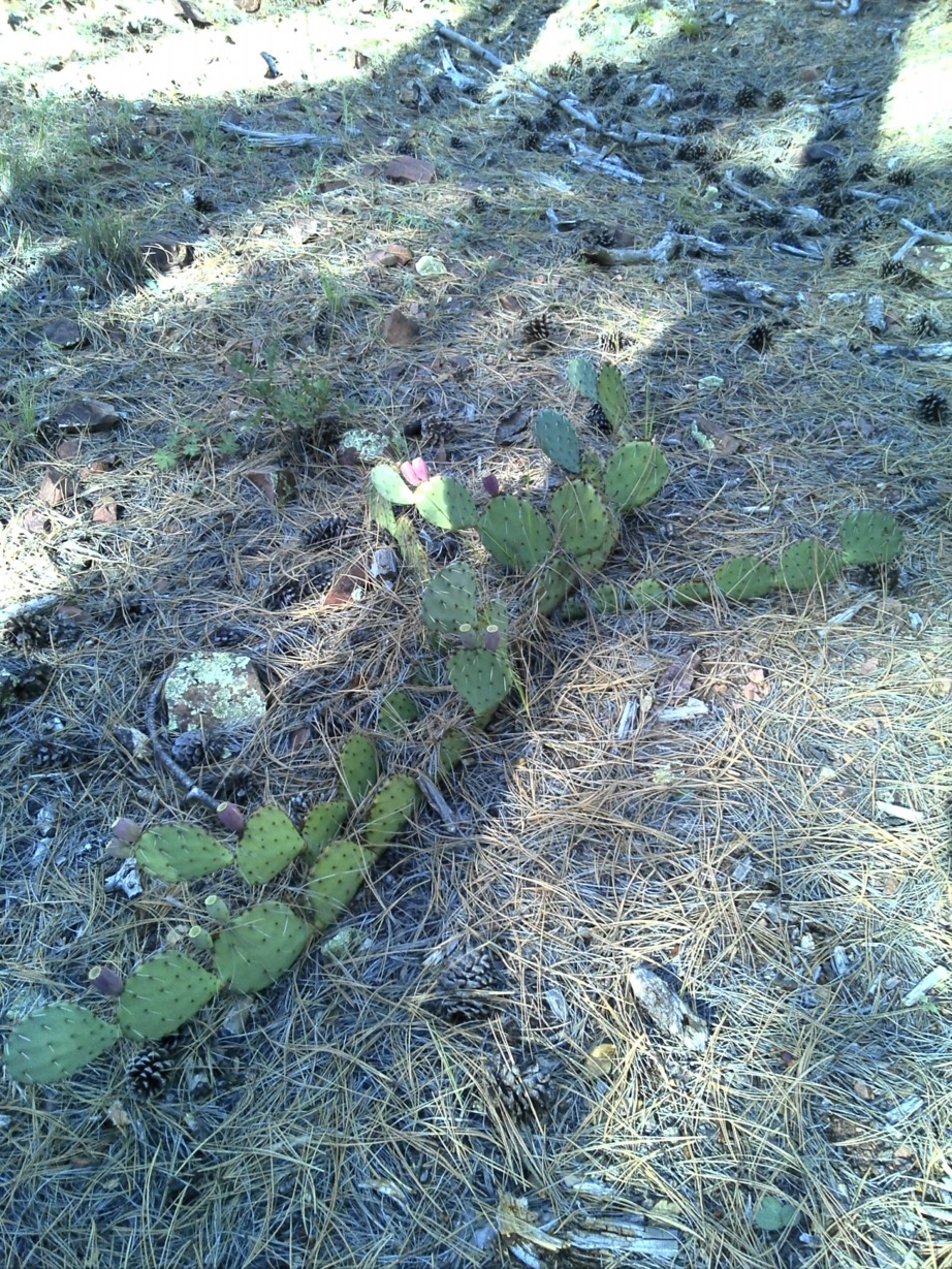
Like an adventitious Adirondack erratic, this prickly pear grew in the forest in the form of a cruciform. Was it planted? A volunteer, like corn in a fallow field? Who can know. Ask her. She’s on first.
At about 5 miles we started hiking down. And down some more. We broke out the hiking poles to help with the descent. This trail is very rough going. It is a hard track, covered in a layer of small to mid-sized rough, angular rocks. From tennis to soft ball size. Very hard to walk on, and very loose when descending (and later, ascending!) steeply. The poles certainly helped.
At 7 miles, I was getting discouraged, as we should have been at the creek. We went down for another half mile before reaching the water.
At the water’s edge, Camille went to sleep on the rocks on the shore. I dumped the gravel out of my shoes that must have been there from last weekend at Wet Beaver Creek, and then I decided to test the water temperature, depth, fauna, etc. So I walked down stream a bit and then into the water, ankle depth. Slowly walking up stream into deeper and deeper flow. At the base of the pool there was a very informal dam of medium sized rocks, and I could sit on one with my legs in the cool, cool water up to my knees, while keeping my butt and above dry. I sat there for quite a while watching for snakes, fish, anything living in the brown, murky, opaque water. Nothing nibbling, striking, swimming or slithering. So I stood up and walked in to my waist, very slowly.
About now Camille awoke and asked me if I wanted to swim. I did. It was about 1:15 pm, and I asked her to keep in mind that we HAD to leave no later than 3:00 pm to get back to the car before dark.
So she started slowly stepping shyly into the water. I took a third step away from shore and was immediately above my head. There’s no telling how deep it was, except it was way deeper than me. I let myself fall into the water to my neck, and it did take my breath away briefly. But keeping my mouth above water I avoided swallowing any. And once the initial shock had dissipated, the water was OK. It would reduce our body core temperatures which would be good for us.
Camille is the stronger swimmer, but I kept up with her until my calf muscle cramped. After fixing that, on we went. The canyon walls rise probably 400’-500’ straight up. The canyon is between 30’ to 100’ wide. You can’t see far upstream since the sections are angular, and only a few hundred yard long each. You had to swim to the next bend to see around it. It was extremely cool swimming upstream in the cool canyon water. A deserted desert paradise beneath a beautiful blue sky, with marvelous designs of lichen on differently geological patterns embedded in the cliff faces. Just completely surreal. Camille kept mentioning that she had always dreamed of doing this. And now we were doing it. Perhaps this was a dream come true?
At the northeast end of the lowest pool (see the Google Earth photo below) there is a shallow shoal, and a small waterfall. We scrambled up and over, over and up, to find another pool. We swam up it to a second waterfall, and again scrambled over it. I was getting a little anxious about the time. Camille wanted to climb one more level. And then one more level. Then I insisted that we turn back.
I was thinking that I should have worn my GPS watch for the swim. It would have been neat to have a track of where we swam and to know the distance as well. In addition, it would have kept me in mind of our need to turn back. I decided to shut the watch off and save the battery for the hike out, since the Montana GPS battery had died on the way in. Although we didn’t need a GPS to hike out, since the trail was fairly obvious to see (in daylight, that is) I wanted to be able to know how far along the path we had gone as we hiked out. So, I left my watch on the shore in my pack before swimming.
Back at the shore, where we’d left our packs, it was 3:16. We still had to eat. We gobbled up 2 tins of sardines, the remaining crackers, and some fruit that Camille had brought - dried figs, dates, and apricots. We kept the Larabars for later, as I was thinking they would be good to eat once at the top of the climb. Kind of as a reward.
After eating, we learned that Camille had drank almost all her water, so I filtered her bladder full. Now it was nearly 4 pm. Even if we could make 2 mph, it would be 8 pm before we got to the car. I figured sunset was going to be about 7, and so we’d have light for walking until about 7:45. If we had reached the old road near the trailhead, this would be OK. I hadn’t packed my very bright headlamps, but I did have a button cell powered LED light in my emergency kit.
We started up steeply, and quickly met a young couple coming down for the night with a small dog. They were a bit surprised that we were hiking out the same day we had hiked in. And they didn’t know we had swum between half mile and a mile.
Up we went. The first mile took nearly an hour. I became very concerned with the dire situation we were in vis-à-vis the remaining daylight. It was clear to me we couldn’t get back before 8:30 earliest. And, it would be foolish to try to hurry on the climb. And the darker it became the more foolish it would be to hurry.
The trail just kept going up and up. We stopped to catch our breath very frequently. I’m accustomed to this, but Camille is not. I was very impressed with her resolve and refusal to show any sign of discomfort. I offered several times to carry her daypack as it was clearly hurting her shoulders, and mine was nearly empty. She refused every time.
Finally at the “top,” it was getting very dim. With still 5 miles to go, I tried to pick the pace up a bit, but it was getting harder to see. And then, the moon shone through a hole in the clouds. We had someone looking out for us, and the hole in the clouds became a clear sky. Before I knew it, I was trying to catch up with my Cat Stevens Moonshadow.
I led us up over the last ridge, and through some sections where the trail was not clear. When confused, I lit the LED and we were usually able to find a sign post, the fence, or signs of the old double track we were following.
After a while, I couldn’t see well, and Camille offered to go ahead. It was much easier following her than trying to see where to walk. We were on the double track now, and she was hard to keep up with. At one point, I was daydreaming or something, and got my feet tangled. There is a point when tipping over that you know you can’t catch yourself, and you begin reacting to land as softly as possible. This usually involves tucking and rolling. I tucked and landed on my right forearm, and when my feet, which were above my head, came down, my right leg did some sliding. This was like most of the trail, a hard trail covered in loose rocks, also hard. Harder than my skin, anyway. It being completely dark, I couldn’t tell what I landed in, only that nothing hurt much, so nothing was broken. Because my head was below my feet (we were walking downhill after all) it seemed like it took forever to get back on my feet. But, nothing but cosmetic and pride damage.
At a few points we got confused by trail junctions and consulted the Hellsgate Wilderness map which just happened to be on the same map as the Salome Wilderness map that I had bought the map for. Good thing I tossed it into my pack the night before. With the GPS dead, we were back to navigating the old fashioned way, with map and compass. But, in the dark, we used the moon and stars for a compass and kept heading north.
We got very confused at the next to last trail junction. It was after 9 pm now, and we were both very fatigued. We sat down on the trail to look at the map and eat a Larabar. Eventually, we found the roads we needed on the map, and convinced ourselves we were on the right track. It just looked so different in the pitch dark. We didn’t remember what we had walked in through. We were close to the parking lot, but my car remote wouldn’t reach to flash the lights for us.
We walked along, and now we could hear the road noise out on 260. We had to be close. We checked the map several more times. The parking lot should be on our right at any moment. All of a sudden the trail began to rise and turn west. This felt all wrong. We shouldn’t be heading west. Camille wanted to try bushwhacking to the right, the east, since we felt that was where the car should be. We walked off the road that way about 50 feet and came to a corner in the fence that we couldn’t cross.
We were confused and I think Camille started being concerned. She had told her folks she’d be home for supper, so she called her Mom and told here where we were. I decided that we were really walking the correct road, and that we should go back to it, and keep walking along. In the dark it’s hard to see very far (or at all!) Possibly the turn to west was immediately followed by a second turn to north that we just couldn’t see. So we did that, Camille leading, and lo and behold, as soon as we climbed up and around the turn, the road went back to the north again.
I tried my remote control again, and the panic lights and horn began blaring, scaring Camille up into the air briefly. But when we realized the car was right in front of us, it was pretty funny.
After a cold beverage, we headed back. Two hours to Camille’s, and then about 30 minutes to mine. I was very tired. I was also glad Camille was asleep in the passenger chair so she couldn’t see how many times I fell asleep and then woke back up. I didn’t count.
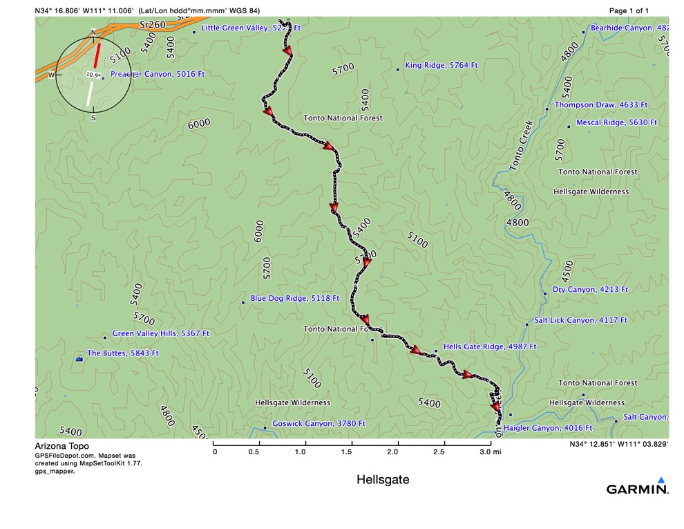
This map shows the 7.5 mile hike into Hellsgate from the trailhead.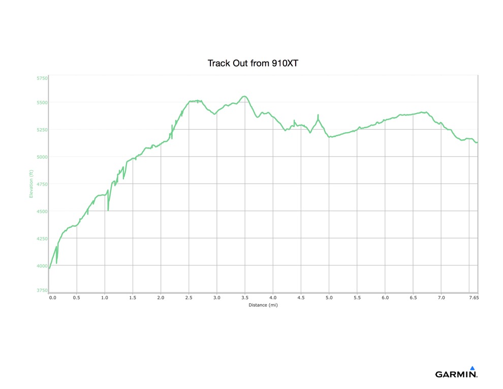
This shows the climb out of the canyon. Not for the faint of heart.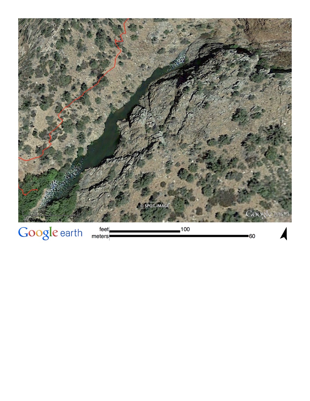
This is a Google Earth aerial view of the canyon. The swim starts near the end of the hiking track and proceeds up river (against a mild but effective current.) About 4 steps away from the bank, the ground drops steeply to some depth way over my head. Canyon walls several feet high straight up.