Hikes in the Superstition Mountains Wilderness
All my hikes in the Superstition Wilderness have been supported by using GPS tracks in my Garmin Montana 650 GPS. These hikes would have been much less safe, and quite likely not possible, had I not “discovered” a thorough set of GPX files on the internet page created by Michael S Thorne. He had hiked all the trails in the Superstitions and recorded excellent GPS tracks of each, with many (hundreds) of waypoints showing potential campsites, water sources, and many other useful subjects. I am very grateful for his work and his sharing of it. His web page is at http://web.utah.edu/thorne/.
First Hike of 2016
Last Hike of 2015
10/4/15 Summiting the Flatiron
Our plan to hike the Superstition Ridge
July 19 Day Hike, Stephen, Camille and Greg
July 6, Cave Trail, Trackwise
My First Double Header - August 29, 2015
Other Day Hikes in July
A grueling, but successful, day hike on June 23.
A number of Day Hikes, once the weather turned too warm to hike much after noon. Not all of these are in the Sups, but they are all day hikes.
March 23-24 I went on another trip in the Superstition Wilderness, hiking out the Peralta Trail and back the way I had come two weeks earlier.
Here is my first hike in the Superstition Wilderness
The plan is below…
10 March 2015
OK, here it is - Plan 0
I’ve simplified and shortened even more, and I’m heading out early tomorrow.
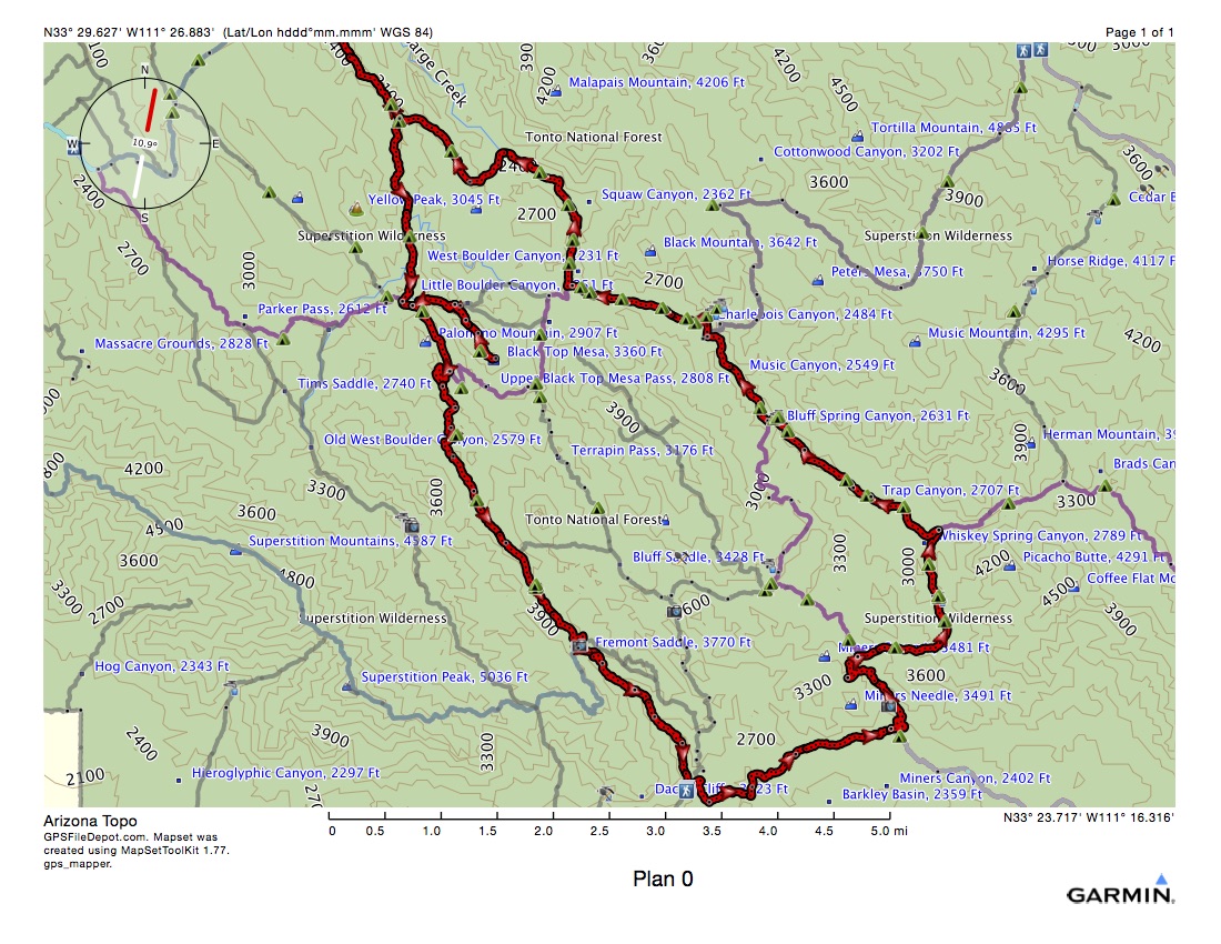
Starting at Peralta Trailhead, at the very bottom, where the hiker waypoint is, walking track-wise.
With a couple of options for the first and third nights, based on distance and elevation.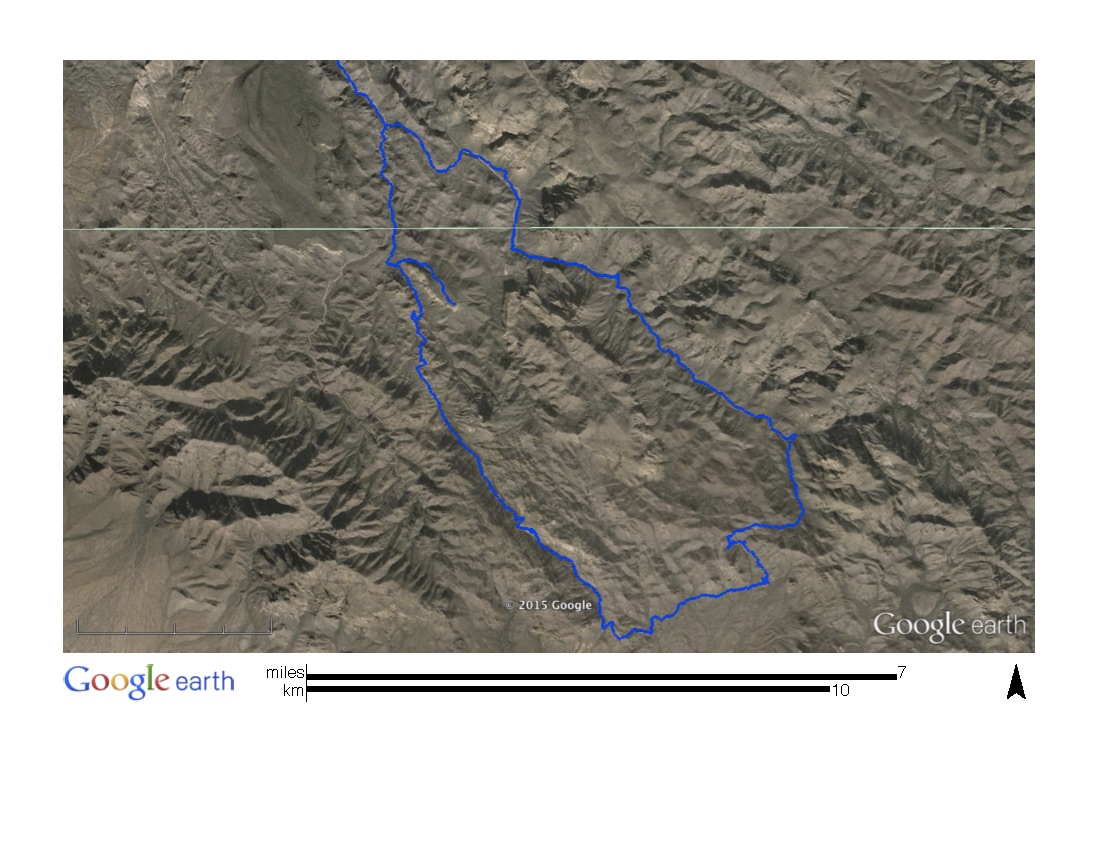
This is what the route looks like in Google Earth with all the lush foliage.
I have options for 0, 1, and 2 night, although the base plan is for 3 nights.
The detailed, boring, way too much information, plan, is below. The bold waypoints are part of the downloaded data. The plan follows a detailed GPX track as well.
Plan 0 (shorter than Plan A or Plan B; same as Plan B to mile 15.9)
Park at Peralta Trailhead. Hike east on trail 104, Dutchman’s, about 2.7 miles, 575’ ascent, 412’ descent, to waypoint CF01, interception with Coffee Flat Trail (108).
At 2.7 miles, keep left (N) on Dutchman’s (104) another 0.7 miles and see Miner’s Needle to west near waypoint DM07 and photo waypoint DM08.
At 3.4 miles continue on Dutchman’s N then NW.
At 4.0 miles, near waypoint DM09 sharp right (E) or switchbacks, then N. Miner’s Needle just E of due South from here.
At 4.3 miles, waypoint DM09, about 3218’ elev, turn Right (E) at junction onto Whiskey Springs Trail 238.
At 4.7 miles, near waypoint WS02, potential campsite.
At 5.4 miles, having turned N, next potential campsite at waypoint WS03.
At 5.7 miles, water source at waypoint WS04 and 2 more potential campsites at waypoints WS05 and WS06. This is the ideal place to stay night 1 if I can get this far.
5.7 miles and 1674’ ascent would be about 3:41 (2 mph, + 1 hour per 2000’ ascent).
At 6.0 miles, still heading N, potential campsite at WS07.
At 6.3 miles, Whiskey Spring Canyon on left.
at 6.4 miles, junction with Red Tanks Trail (107). Turn left (W) here at waypoints WS08 and RT12. This is the end of the Whiskey Spring Trail (238) where it tees into the Red Tanks Trail (107). Red Tanks Trail goes right (NE) but I turn left (SW) here.
Skirting Barge Creek on left, trail passes Upper LaBarge Box Canyon on left (S) then bends to the right heading now NW.
At 6.9 miles, trail turns due West near waypoint RT11, a potential campsite.
At 7.3 miles, trail passes through Trap Canyon near potential campsite RT09.
At 7.5 miles, potential campsite at waypoint RT07, near Barge Creek on left (S).
At 8.0 miles, trail bends due N, then NW again, near waypoint RT06.
At 8.3 miles, potential campsite RT05.
At 8.4 miles, sharp left (SW) and cross Barge Creek, then skirt it NW on west side of creek.
At 8.5 miles, water source and 2 potential campsites, RT02, RT03, RT05.
At 8.6 miles, junction with Dutchman’s Trail (104). This is terminus of Red Tanks Trail (107). Dutchman’s coming up from the south (and my starting point), I turn right (N) at waypoints RT01 and DM19. This is another option for night 1 if the timing is right. It would take a total of about 5:10 to hike here without stops.
Potential bail out A (below) here by turning left (S) on Dutchman’s (104) it is about 8.0 miles and 1857’ ascent back to car. This would take about 4:56 to hike.
At 8.7 having crossed Barge Creek again and turned N, potential campsite at DM20.
At 9.1, Music Canyon on right (E) and farther, Music Canyon Spring.
At 9.3, cross Barge Creek again and then turn due N.
At 9.6, near points DM21 and PT16, intersection with Peters Trail (105) after turning due W. Continue North on Dutchman’s (104).
At 9.8 miles, sharp CCW turn from N to S, near potential campsite DM22. CHAR side trail on right (NE) leads 100 yards NE to Charlebois Spring (DM23), and then another 300 yards to potential campsite DM24.
At 11.2 miles, junction with Cavalry Trail (239) at DM31 and CV08. Dutchman’s bends south here, but I stay straight (W) on Cavalry Trail, then it makes a sharp right (N).
Potential Campsite CV07 at 11.4 miles.
Potential Campsite CV06 at 11.7 miles.
Potential Campsite CV05 at 12 miles.
Potential Campsite CV04 at 12.5 miles.
Cavalry Trail turns south and crosses La Barge Creek.
Cavalry Trail turns west, then northwest near CV03.
Potential Campsite CV02 at 13.8 miles.
End of Cavalry Trail at 14.4 miles, near CV01 and BC14. Turn right (N) on Boulder Canyon Trail (103). Potential campsite BC15 is just south.
Potential to camp here. Make camp, then hike to mile 15.9 (below) and back. Then head south the next day… would be a 3 mile round trip… it’s counter below, but I could skip it altogether…
Potential Campsite BC13 at 14.6 miles.
May pass trail to Battleship Saddle on right at 14.7. May be potential for high water as I pass through (NW) Boulder Canyon.
May pass trail to Second Water Springs on left (SW) at or near 15.2 miles.
At 15.9 miles, just after potential campsite SW12 on right, near BC12 and SW11, turn left (W) at junction with Second Water Trail (236). This may be a good place to stop for the second night, as the next potential campsite is not until mile 17.3.
Hike back to junction of Cavalry Trail near CV01 and BC14. That will be 17.4 miles.
Probably start Day 3 from here…
Continue south 1.1 miles on Boulder Canyon Trail (103) to mile 18.5, where Needle Canyon is on left (E).
Potential campsite at BC16 at 18.7 miles.
In another 0.2 miles at 18.9 miles, West Boulder Canyon is on right (W). Trail then enters Little Boulder Canyon.
At mile 19.3, reach end of Boulder Canyon Trail (103) and junction with Dutchman’s Trail (104) which I will south.
At mile 19.5, turn left (E) onto Bull Pass Trail (129). May want to cache backpack here, because I am going into a box canyon to see the sights, and coming back this way, then continuing on south.
At 20.0 miles, turn right (S) onto Spanish Hieroglyphics Trail near BP02 and SH01.
Potential campsite at 20.6 miles, SH05. If I brought my pack with me, cache it here, and make camp for night 3 here. Then watch the sunset from Black Top Mesa summit.
Reach summit of Black Top Mesa at 20.7 miles, 3360’. Turn around and backtrack back to Dutchman’s.
Back at Dutchman’s, turn left (S), mile 22.0.
DM40 potential campsite at mile 22.1 Also called Aylor’s Caballo Camp, 2313’.
If this is still the third day and I didn’t spend the night on Black Top Mesa, and unless I am ready to hike 7 more miles with a 1500’ ascent in the middles of it, I should spend the night here.
At 22.7 miles, PR17 and DM39, turn right (SW) onto Peralta Trail (102.)
At mile 25.3, Weaver’s Needle Crosscut trail comes in from left (NE).
At 26.7, cross junction with Dacite Mesa, Robber’s Roost, Weaver’s Outlook, Cae Trails. Continue SE on Peralta.
Reach car at 29.0 miles, 6551’ ascent and descent.
I began planning hikes in the Superstition Wilderness area in anticipation of completing all the South Mountain trails in day hikes. The Superstition Wilderness is located in the Tonto National Forest and managed by the US Forest Service.
Dad and I drove out to locate 5 of the southwesternmost trailheads on a Sunday afternoon. Most importantly we found the Peralta Trailhead where my initial hiking in this area will start and end.
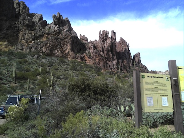
at the Peralta Trailhead
I had purchased a map of this area at REI, and Dad & Judy gave me a book describing many of the trails in this area. I also found extremely complete GPS data at this URL: http://web.utah.edu/thorne/superstitions.html and downloaded it into BaseCamp. Using that data, I was able to complete some detailed plans for backpacking trips.
Plan A is my first plan. It totals 52.9 trail miles, about 12,000’ ascent and descent, embarking from Peralta TH, and would take 4-5 days of backpacking. Here are a couple graphics:
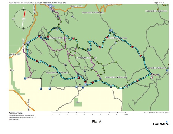
Plan A map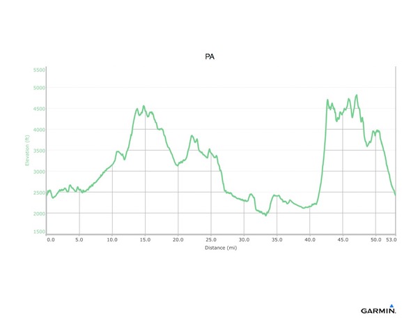
Plan A Elevation Profile
While this certainly looks possible to complete in 4-5 days of hiking, it will be challenging. I know I have to be aware of finding enough water, as I couldn’t possible carry enough. Looking at the map, I see there are lots of potential campsites and water sources in the center of the map, but very few on the farther eastern route planned.
After my last day hike at South Mountain, I drove over to the Tonto National Forest HW in Phoenix. I was able to purchase my senior pass ($10 for life) granting free access to all National facilities, and I also purchased 2 terrific maps for $10 each. These are the US Forest Service maps for the Superstition Wilderness and the Mazatzal Wilderness, farther north. They are large maps printed on polyester. The ranger I spoke with suggested the Mazatzal. It’s much higher, and has trees!
In any case, I decided to rough out a Plan B, shown below.
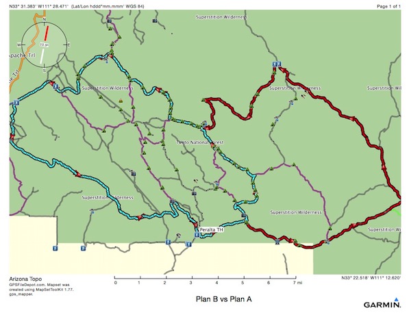
Plan B (cyan) vs Plan A (red + cyan)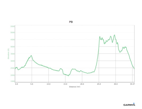
Plan B Elevation Profile
Plan B is a total of 37 miles, and about 8800’ of ascent and descent. It would be possible to hike it in 3-4 days, but, I’m not really interested in hiking fast. More importantly, I am interested in finding potable (treatable) water, avoiding tumbles (stumbles will have to be OK). And avoiding people, mostly. I would probably leave on a Monday and try to be coming home on Saturday. There is a lot of day hiking in the area now that temperatures have still not risen to summer levels.
The ranger did tell me the snakes are beginning to come out of hibernation, so I will need to be mindful of where I step. I usually am because my balance is fairly poor. He confirmed my plan to filter water, to stay found, and said I would do fine.
I plan to use my bughut, sleeping pad and a 20 degree bag, as there are few if any trees from which to hang a hammock. I’ll use my alcohol stove for boiling water, no campfires, and plan to live on oatmeal, dehydrated meals, and whatever packaged snacks I can carry. I also plan to hike in my Asolo light hiking (not the leather ones) boots. I’ve completely destroyed the trail running shoes I’ve used at South Mountain, as they now destroy my feet whenever I use them I expect the Superstition Wilderness will be rougher than South Mountain.
More later…