Backpacking Loop from the Woodbury Trailhead
Here is a long dialog written while planning this trip. If I make this trip, it probably will not work out this way, but, it is good to plan things like this.
I would like to park at the Woodbury trailhead (trailhead 26 in my GPS data.) Suzy and I are planning to drive out there on a weekend day to “scout” the way to get there. Assuming this works, I will park at this trailhead.
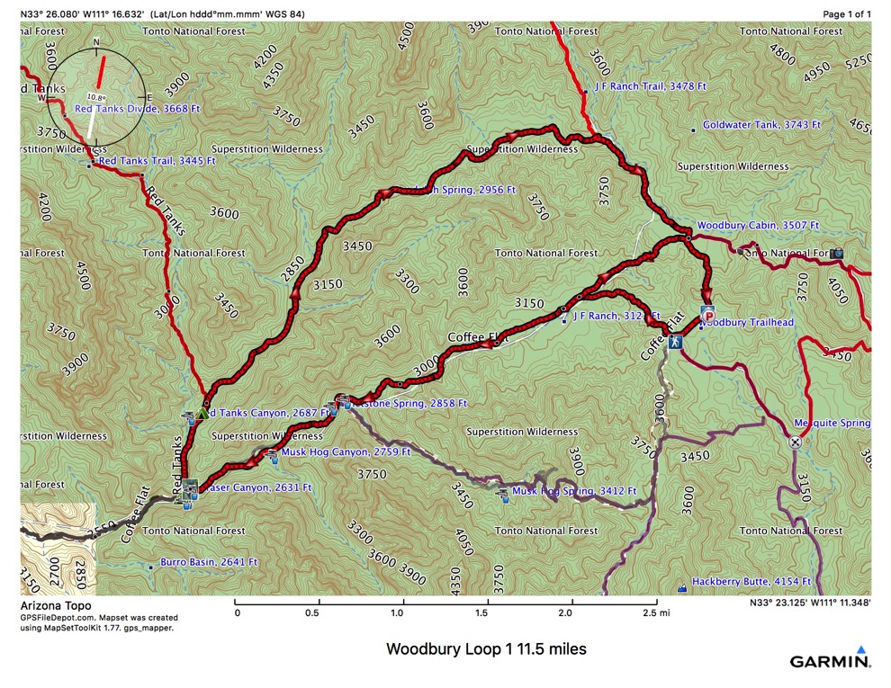
According to the book, Hiker’s Guide to the Superstition Wilderness by Jack Carlson and Elizabeth Stewart “At the parking lot, the old dirt road to the Woodbury Cabin site is blocked to vehicles. Heading north, a half mile up the dirt road from the parking lot brings you to a signed trail junction where the JF Trail goes straight ahead (north) toward the windmill. The Woodbury Trail (114) goes east from here 1.3 miles to FS172A and west one mile to the JF Ranch Headquarters and the Coffee Flat Trail (108). “
The first task will be to hike with my overnight pack north on FS172 about 0.3 miles to the JF (106) trail. Then 0.6 miles north on this to reach the Woodbury Cabin. Here I will find a place to secrete and cache my overnight pack. Then hike the mile back to the car.
The gives me a chance to adjust my shoes and gaiters, and anything else needing it. Back at the car, I can tank up on water from a cooler and drink as much as I can. Then I will head out with a daypack for this “loop”:
FS172B 0.7 miles to junction with Coffee Flat Trail (107). “From the west side of Woodbury Trail parking lot, follow FS172 to the top of the hill where FS172B is blocked by a locked gate. Climb over the gate and continue down FS172B to the wash in Fraser Canyon and on to the JF Ranch Headquarters corral.” This part is 0.7 miles and should take a half hour or less.
Coffee Flat Trail (108). This is kind of the purpose of this loop - to let me finish the Coffee Flat Trail. I’ve hiked all of it west of the junction with the Red Tanks Trail. “ The Coffee Trail (108) heads around the north side of the corral, but if you have time you can take a side trip across the sandy wash to the JF Ranch buildings. At JF Ranch, the enormous Fremont cottonwood trees along the sandy creek bed provide a pleasant canopy of shade, although a few trees have lost their footing in the eroding soil. If the windmill is in operation, there may be water here, but don’t count on it. The old barn and outdoor blacksmith shop are interesting to examine and photograph. JF Ranch is still a working cattle ranch. Please respect the private property.
The signed Coffee Flat Trail (108) starts at the north side of the big corral. The trail goes through a closed gate, then follows the corral fence west on the north side of Fraser Canyon. At the corner of the fence line, the trail heads toward Fraser Canyon. You can enter the wash here or continue on the trail that stays on the north bank. The big Fremont cottonwood tree that hikers and horse riders use as a landmark is in the bed of the wash just to the south of here. Fraser Canyon usually has seasonal water after a rain.
The trail crosses Fraser Canyon many times but the crossings are well marked by large rock cairns. On the map, in several places, we drew the dashed line down the center of the wash since it is almost impossible to keep track of the many crossing. Horse riders have kept the vegetation from invading the trail, and the walking is fairly easy. Hikers can elect to walk down the bed of the wash or follow the trail. The horse trail bypasses some of the old freight road along one section of trail.
The trail is on the north side of Fraser Canyon when it passes the mouth of Whetrock Canyon, so you will miss this drainage if you are not looking for it. Trip 51 describes a difficult trek up Whetrock Canyon. [I do not plan to explore Whetrock Canyon on this trip, other than possibly peeking through the drainage.] About 15 minutes west of Whetrock Canyon, the trail enters the creek bed where twelve willow trees grow in a line down the wash. The Tonto National Forest map is the only map that shows a spring here - Whetstone Spring. Don’t count on Whetstone Spring for water. The trail then follows the south bank and crosses the drainage at Musk Hog Canyon. Musk Hog Canyon may have seasonal water. Small groves of sugar sumac, Arizona sycamore, and mesquite dot the canyon floor as the trail continues west. Overnight trekkers will find several flat places to camp between Musk Hog Canyon and Dripping Springs.
A hundred feet or so west of a large Fremont cottonwood tree blocking the north channel of the wash in Fraser Canyon, you will pass the Coffee Flat Trail sign. The Red Tanks Trail (107) sign is another fifty feet to the west. The trail intersections and signs, on the northeast bank, are easy to find. The junction of Fraser and Randolph Canyons is very pretty. The smooth, reddish bedrock, shallow pools of seasonal water and openness of the canyon make this a special place. Dripping Spring is a short distance southwest in Randolph Canyon. Dripping Spring is on the south wall of the canyon where water drips from the ledges into the wash. From the spring, looking north across Randolph Canyon, there is a small cave in the low cliff. The cave, with a low ceiling, extends back 40 to 50 feet. The flat bench along the creek below the cave offers flat camping and a shady place for lunch.” This part is 2.9 miles and should take an hour and a half. Total walking since car of 2 hours. Just for water planning purposes.
Red Tanks Trail (107) and Randolph Canyon. “From the trail sign at the junction of Coffee Flat Trail and Red Tanks Trail head north on the Red Tanks Trail (107). The trail begins on the east side of Randolph Canyon and soon enters the bed of the wash. Someone has spray-painted a blue arrow on the white rock in the center of the wash. Please don’t paint the rocks. The trail goes on the west bank - another blue arrow. Back in the creek bed, the trail passes a blue arrow near some seasonal pools of water before heading up a steep slope on the east side of the canyon. The trail climbs high above the canyon floor and then turns northeast as it follows Randolph Canyon. Some hikers may enjoy walking along the smooth rock canyon floor rather than taking the trail over the hill.
The trail drops down to creek bed level on the first flat bench after Randolph Canyon turns northeast. Several trails of use are here, so make your best guess and cross to the north side of Randolph Canyon where you pick up the trail at the wooden trail sign. This is one of the few trail signs that still show trail mileages - Fraser Canyon 0.5, and LaBarge Canyon 3.5. The Red Tanks Trail heads uphill (north) to Red Tanks Canyon. Our trip leaves the trail and follows the bed of Randolph Canyon. No continuous trail goes up Randolph Canyon, so the best plan is to walk up the creek bed and make us of the old cow trails on the bench.
Randolph Spring which has seasonal flow is easy to find if you are following the creek bed. A cement dam, back-filled with rock, spans the wash at Randolph Spinrg. Several large willows grow here. The wash goes through a narrow, smooth rock section, so we walked up the south slope where we found an old trail that took us a good distance up Randolph Canyon. This may have been the unimproved trail shown on the USFS Superstition Wilderness map. After crossing a ravine, we lost the trail which may have turned south toward JF Ranch. Continuing on the south bank of Randolph Canyon, we soon crossed a closed gate in a broken fence before dropping into the creek bed.
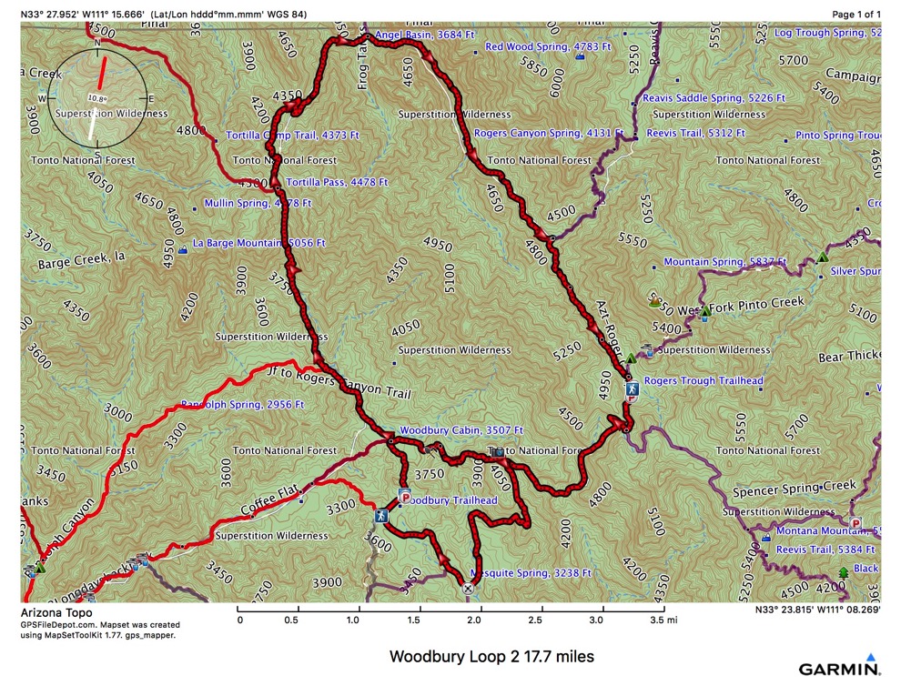
JF Trail (106) crosses Randolph Canyon where a large wash enters from the north. There are no signs here, but you can see the eroded trail heading up the red dirt bank to the south. From here it is smooth walking. The trail goes up the hill, crosses the wash twice, then passes the wooden Tonto National Forest Superstition Wilderness sign. About 30 feet south of the Wilderness Boundary sign is a trail heading west to the JF Headquarters. This trail is the old alignment for the JF Trail and connects with Woodbury Trail (114) and Coffee Flat Trail (108) to the southwest. Proceed south on the JF Trail toward the Woodbury Windmill. In December of 1993 the windmill seemed to be in operation, but no water was coming out of the pipes. The trail near the windmill is very faint, but becomes more distinct as you proceed south to the signed junction with Woodbury Trail (114). The JF Trail follows the dirt road over a small hill to the parking lot at Woodbury Trailhead.“
I plan to hike south on the JF Trail only to retrieve my backpack that I cached earlier. Then back north on the JF Trail...
By this point I will have hiked 0.9 miles with my backpack, and 9.6 miles with only a daypack. The 9.6 miles should take about 4-5 hours if I don’t dawdle too much. I will try to take 4 L of water (8.8 pounds). Of course, if I have hot spots or other ailments, I would just bail out here. If not, I till head back north on the JF Trail, described in the book as “
continue north on the JF Trail, walk to the left (west) of the Woodbury windmill and pass a severely-weathered green sign and metal post that reads TRAIL. Although there are many flat places to camp along the trail near the windmill, the cows have made claim to the area. The trail becomes more defined as it passes the Wilderness Boundary sign. The old alignment of the JF Trail (from JF Headquarters) comes in from the west about 30 feet south of the Wilderness boundary sign. After crossing Randolph Canyon Wash twice, the JF Trail follows the west bank of Randolph Canyon and passes along a hill side dotted with honey mesquite, sugar sumac, single-lea pinyon, red berry buckthorn and mountain mahogany. Potholes of water in Randolph Canyon are not potable due to the cattle in the area. After crossing the bed of Randolph Canyon, the trail heads uphill across the ridge through prickly pear, ocotillo, jojoba, saguaro and mesquite. Farther up the hill, the trail is surrounded by a dense growth of mountain mahogany, sugar sumac, juniper and shrub oak. At the signed junction on Tortilla Pass, we leave the JF Trail as it turns west through a closed gate. This trip follows the Rogers Canyon Trail (110) which begins at Tortilla Pass.
From Tortilla Pass proceed north up to a higher pass on Rogers Canyon Trail (110), then descend a short, steep section of eroded trail. After the trail crosses a small drainage, the trail conditions improve and you may find some water here after a rain. Farther down this wash there may be a few seasonal potholes of water. The trail continues down to the canyon floor, passing through a patch of catcall acacia, before meeting the seasonal stream bed of Rogers Canyon. Across Rogers Canyon drainage, you can see a large inviting grassy area where a wooden sign marks the junction with Frog Tanks Trail (112). This is Angel Basin [where I may spend the evening]. Large Arizona black walnut, net leaf hackberry and Arizona sycamore trees shade this ideal camping area. The Rogers Canyon cliff dwellings are about 0.3 miles east in Rogers Canyon. From the grassy area follow the Rogers Canyon Trail east as it crosses the drainage several times. There are more ideal camping places along here under the large emory oaks. When the trail starts to go uphill, look across the canyon to the north and you will see the cliff dwellings in a cave. The cliff dwellings are located on the north side of the canyon about 100 feet up from the bottom of the wash. A rough trail goes steeply up the slope to a Forest Service sign that provides some useful information.
| Trail | Dist | Ascent | Descent | cum miles | cum asc | cum des | Dir | |
| FS172 | 0.3 | 51 | 28 | pack | 0.3 | 51 | 28 | N |
| JF Trail (106) | 0.6 | 93 | 123 | drop backpack here | 0.9 | 144 | 151 | N |
| JF Trail (106) | 0.6 | 123 | 93 | back to car | 1.5 | 267 | 244 | S |
| FS172 | 0.3 | 28 | 51 | get day pack, water | 1.8 | 295 | 295 | S |
| FS172B | 0.7 | 17 | 334 | day, W to CF 108 | 2.5 | 312 | 629 | NW |
| Coffee Flat 108 | 2.9 | 144 | 628 | to Red Tanks junx | 5.4 | 456 | 1257 | SW |
| Red Tanks (107) | 0.6 | 129 | 64 | 6 | 585 | 1321 | N | |
| Randolph Canyon | 3.5 | 708 | 159 | 9.5 | 1293 | 1480 | NE | |
| JF Trail (106) | 1 | 224 | 31 | get pack | 10.5 | 1517 | 1511 | SE |
| JF Trail (106) | 1 | 31 | 224 | back north | 11.5 | 1548 | 1735 | NW |
| JF Trail (106) | 1.9 | 1244 | 54 | 13.4 | 2792 | 1789 | N | |
| Roger’s Canyon (110) to Angel Basin | 2.3 | 247 | 1015 | down | 15.7 | 3039 | 2804 | NE |
| spend the night here | ||||||||
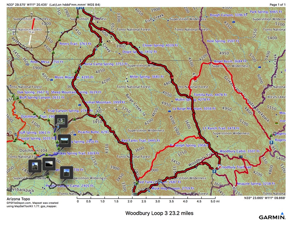
| Roger’s Canyon (110) rest of trail | 2.7 | 770 | 71 | then up | 2.7 | 770 | 71 | SE |
| Reavis Ranch Trail (109) | 1.6 | 461 | 20 | 4.3 | 1231 | 91 | SE | |
| FS172A | 3.9 | 1797 | 164 | road ? | 8.2 | 3028 | 255 | E, S |
| Woodbury Trail (114) | 1.2 | 14 | 566 | 9.4 | 3042 | 821 | W | |
| Woodbury Trail (114) | 1.2 | 566 | 14 | 10.6 | 3608 | 835 | E | |
| FS172 | 0.3 | 27 | 42 | 10.9 | 3635 | 877 | ||
| maybe a side loop if I feel like it | 10.9 | 3635 | 877 |
Reading and thinking are helpful planning tools. After reading all that, typing it in, and thinking about it, I have a revised plan. Instead of packing my pack up a mile and caching it, then heading back to the car, why not make the loop first, all the way back to the car, then get the backpack and head up north for the overnight trip? Or even, make this into 2 separate loop day hikes?
Here are 3 loops I could hike, either in a single multi-day trip, or several day hikes.
Stuff for my overnight (ULA Circuit) pack:
hammock
tarp
stove
fuel
pan & lid
mug
windscreen
food - coffee, oatmeal, soup, figs, nuts, raisins, sardines
headlamp
USB cables and battery
candle lantern
lighter
water
Stuff for my daypack
Ten essentials
water filter
bladder
compass
trail book
GPS
iPhone
sunblock
spare sox
gaiters
Here are some details for this version:
There may be many potential hammock sites near Angel Basin, at about mile 15.7. This would make e nice day, 15.7 miles, but only about 6 with the overnight pack. If I could hang here, I wouldn’t need a tent. This time of year I wouldn’t need a tarp or an under quilt. If I can find water. Of course, I should take the tarp for shade.